
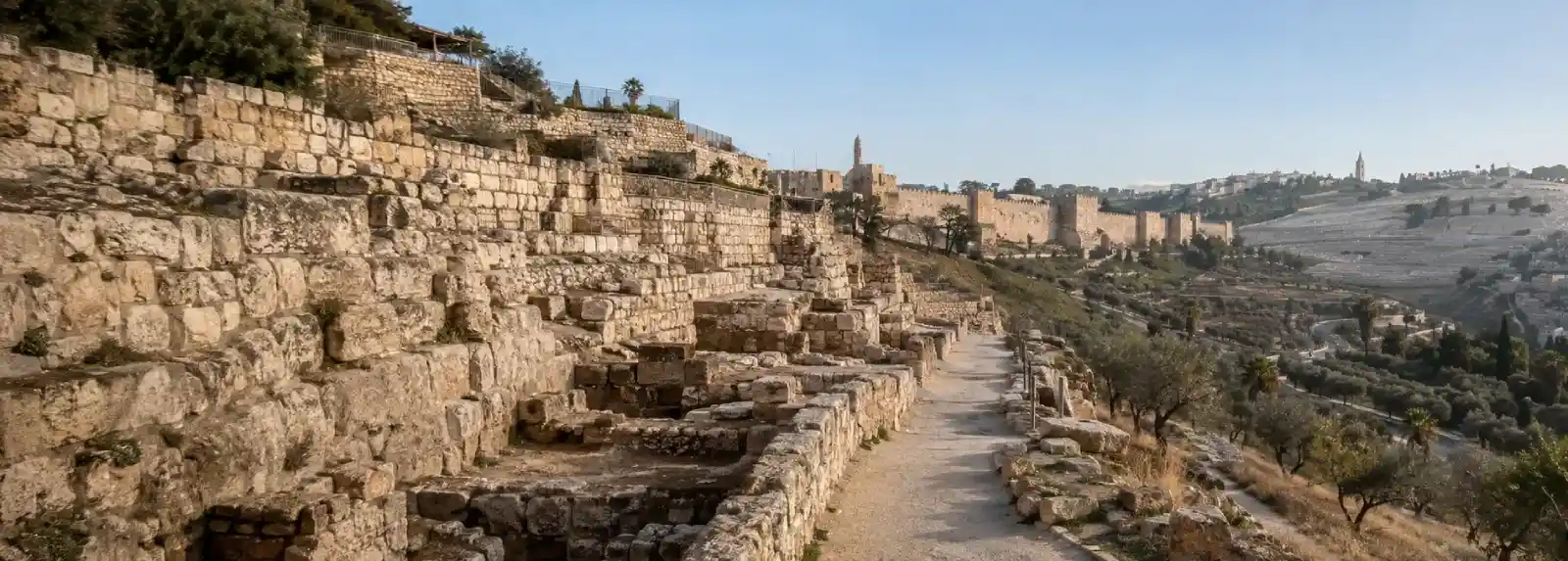
A visit to the City of David and Jerusalem Walls is an invitation to read Jerusalem from below the postcard. The route descends toward the ancient ridge south of the present-day Old City, where excavations, water channels, retaining walls, and later streets reveal how a settlement grew around a difficult landscape. You will not see one uninterrupted biblical scene. You will see fragments, reconstructions, active neighborhoods, and archaeological interpretations placed beside one another. That combination is what makes the area so rewarding for visitors who want to understand how the city was built.
The City of David is associated with one of the earliest urban cores of Jerusalem. The Israel Nature and Parks Authority describes the wider Jerusalem Walls National Park as including the City of David, the Gihon Spring, Hezekiah’s Tunnel, the Pool of Siloam, the Ophel excavations, and other archaeological areas. Those names can make the route sound like a checklist, but the landscape is easier to understand if you treat it as a sequence of problems and solutions. Where could people build? How did they reach water? How were slopes stabilized? How did the city connect its defended ridge to the valleys below?
Read the ancient ridge as a landscape
Begin by orienting yourself to the topography. The ridge is narrow, and the ground falls away toward the valleys on either side. That shape mattered to early settlement because a defensible high point could also create serious limits. Flat building land was scarce, movement was constrained, and water could not simply be assumed. When you look from an overlook or along an excavated path, try to see the slope before focusing on an artifact. The city’s earliest choices were responses to ground, visibility, and access.
Archaeology here works through layers rather than a single date. Stone courses may belong to different periods, a wall may have been repaired, and a modern visitor path may pass through a place that once served a completely different purpose. Signs and guides help distinguish evidence from interpretation, but you can also practice the distinction yourself. Notice what is physically present, what has been reconstructed, and what is being inferred from a small number of remains. This habit makes the visit more interesting and protects the past from being presented as simpler than it was.
The excavated areas around the City of David and the Ophel are especially useful for seeing how a capital accumulates infrastructure. Platforms, walls, steps, channels, and streets are not decorative background. They show the labor required to move through a steep city and to connect public, religious, residential, and defensive spaces. Even when a ruin is difficult to identify, its scale can communicate something important. A massive retaining wall speaks about construction and authority. A narrow stairway speaks about repeated movement. A water channel speaks about planning under pressure.
Follow the water into the story
The Gihon Spring is central to the area’s archaeological logic. A spring at the foot of a ridge could sustain settlement, but it also created vulnerability if people had to leave the city’s protected area to reach it. Over time, water systems were developed, altered, and extended. The best-known visitor experience is Hezekiah’s Tunnel, a water channel cut through rock and associated with the effort to bring water toward the Pool of Siloam. The tunnel is more than an adventurous passage. It is evidence of engineering, labor, surveying, and the political importance of reliable water.
If you plan to enter a water tunnel, think about the physical experience before buying a ticket. Darkness, low ceilings, uneven footing, and water underfoot can make the route unsuitable for some travelers. Carry only what you can keep secure, wear shoes with a dependable grip, and check current requirements. A dry route or guided explanation can still make the water system legible if the tunnel itself is not the right choice for your group.
The Pool of Siloam and nearby excavations extend the story beyond the spring. Water had to arrive somewhere people could collect it, use it, and connect it to the life of the city. A pool is not only a biblical reference or a photograph. It is part of an urban system. As you move between water, walls, and streets, consider how infrastructure turns a difficult hill into a place where many people can live over long periods.
Understand the walls as changing boundaries
Jerusalem’s walls are often imagined as a single continuous defense, but the visible walls around the Old City belong to a later Ottoman period and sit within a much longer history of fortification, rebuilding, expansion, and change. The City of David is outside the current Old City walls, even though it is closely connected to the city’s ancient history. That distinction is important. A visitor can move from the ancient ridge to the later wall line in a short distance, but the two places should not be collapsed into one archaeological moment.
Walk the area as a study in thresholds. A gate controls movement. A wall organizes visibility. A slope creates distance. An excavated street exposes a former route while a modern road carries traffic above it. These relationships help explain why the Old City and the City of David feel both close and separate. They are connected by history, but they also represent different phases of the city’s physical organization.
It is also worth remembering that archaeology takes place in a living and contested city. Excavations can illuminate the past, but the way sites are named, interpreted, displayed, and connected to present-day claims can shape what visitors think the evidence means. Read the site’s labels carefully, distinguish archaeological findings from religious tradition, and seek more than one framing when a question is politically or historically contested. Curiosity is stronger when it leaves room for uncertainty.
Build a route that leaves time to look
A focused visit can begin at the City of David visitor area, continue through the archaeological sections and water story, and then connect toward the southern edge of the Old City and the Western Wall area. Some visitors will prefer a guided tour, especially if they want help reading the excavations or navigating the tunnel options. Others may choose a self-guided route with fewer stops and more time at overlooks. Both approaches work when the schedule leaves room for the site’s topography.
Pair this guide with A First Walk Through Jerusalem’s Ancient Quarters or the guide to the four historic quarters if you want to compare archaeological space with the living streets inside the walls. The contrast is useful. The City of David foregrounds excavation, infrastructure, and early urban growth. The Old City routes foreground markets, religious practice, neighborhoods, and later layers that remain active today.
Before you go
Reserve activities and check current access information before visiting. The Israel Nature and Parks Authority notes that opening arrangements, site facilities, and available experiences can change. Tunnel access may involve separate tickets, time slots, or equipment requirements. Do not plan a tight connection between the City of David and another site if your day depends on a particular entry time.
Wear shoes suitable for stone paths, stairs, and uneven surfaces. Bring water, protect yourself from strong sun, and consider the temperature difference between an exposed archaeological area and a cool tunnel. Visitors who do not want a demanding route can still enjoy overlooks, explanatory displays, and nearby archaeological areas without attempting every passage.
Give the excavations the same respect you would give a working neighborhood. Stay on marked routes, do not climb fragile remains, and follow staff instructions. The surrounding streets are used by residents and worshippers, so keep entrances clear and avoid treating people’s daily lives as scenery. A careful visit leaves both the archaeological site and the living city easier for the next traveler to understand.
The City of David and Jerusalem Walls are most memorable when you stop looking for one dramatic answer. Instead, follow the relationship between ridge, water, wall, street, and valley. Jerusalem’s earliest urban story becomes clearer when the landscape is allowed to speak through its constraints, its engineering, and the traces of many later generations.
References & Visitor Notes
The archaeological places and current visitor guidance in this article are informed by the Israel Nature and Parks Authority guide to Jerusalem Walls and City of David National Park, the iTravelJerusalem half-day Old City itinerary, and the Western Wall Heritage Foundation visitor information. Check official access and ticketing information again before visiting.